• InfoWater Pro

Extracting elevation

Populate junction elevations using the raster elevation dataset.


Tutorial resources

These downloadable resources will be used to complete this tutorial:


00:03

When you import a model and make manual fixes and adjustments,

00:07

junctions may not have elevation data.

00:10

The info water pro elevation extractor can be used

00:13

to populate junction elevations using the raster elevation data set

00:18

to begin

00:19

double click the desired project dot APR file to open

00:23

Agis pro.

00:25

Once the project starts,

00:26

click the info water pro tab to open the info water pro ribbon

00:31

in the project panel, click initialize

00:35

from the arc

00:36

GS pro toolbar in the layer panel. Click add data

00:42

in the add data,

00:43

dialogue browse two and double click the desired dot GDB file to

00:47

expand it such as city data dot GDB for this exercise.

00:52

Then select the raster dataset you need in this case elevation

00:56

and then click OK

00:59

on the info water pro ribbon in the edit panel, click DB editor,

01:04

the DB editor opens showing the opentable junction demand modeling data dialogue

01:11

in the data table. Tab expand the element information data folder,

01:16

double click junction information.

01:18

Now the junction information table populates the DB editor

01:22

notice that the elevation column is empty.

01:25

Close the DB editor,

01:28

you can use the elevation extractor to populate the elevation information

01:32

but be aware that this tool only accepts raster files

01:35

from the command center tab in the model explorer, expand the tools folder,

01:40

then double click elevation extractor

01:44

in the elevation extractor dialogue, set the source layer to elevation

01:48

and then click extract.

01:51

If you do not see elevation listed here as a layer,

01:54

then the elevation data is likely in another file type.

01:58

The elevation extractor takes the value

01:60

of the pixel corresponding to each junction

02:02

and assigns it in the elevation field of

02:05

the info water pro information database table.

02:08

When you see a confirmation in the message

02:10

board that the elevation data extraction is finished,

02:13

you can close the extractor

02:16

reopen the database editor by selecting DB editor element information, data

02:21

junction information.

02:23

And you can see that elevation data is now contained in the database table.

Video transcript

00:03

When you import a model and make manual fixes and adjustments,

00:07

junctions may not have elevation data.

00:10

The info water pro elevation extractor can be used

00:13

to populate junction elevations using the raster elevation data set

00:18

to begin

00:19

double click the desired project dot APR file to open

00:23

Agis pro.

00:25

Once the project starts,

00:26

click the info water pro tab to open the info water pro ribbon

00:31

in the project panel, click initialize

00:35

from the arc

00:36

GS pro toolbar in the layer panel. Click add data

00:42

in the add data,

00:43

dialogue browse two and double click the desired dot GDB file to

00:47

expand it such as city data dot GDB for this exercise.

00:52

Then select the raster dataset you need in this case elevation

00:56

and then click OK

00:59

on the info water pro ribbon in the edit panel, click DB editor,

01:04

the DB editor opens showing the opentable junction demand modeling data dialogue

01:11

in the data table. Tab expand the element information data folder,

01:16

double click junction information.

01:18

Now the junction information table populates the DB editor

01:22

notice that the elevation column is empty.

01:25

Close the DB editor,

01:28

you can use the elevation extractor to populate the elevation information

01:32

but be aware that this tool only accepts raster files

01:35

from the command center tab in the model explorer, expand the tools folder,

01:40

then double click elevation extractor

01:44

in the elevation extractor dialogue, set the source layer to elevation

01:48

and then click extract.

01:51

If you do not see elevation listed here as a layer,

01:54

then the elevation data is likely in another file type.

01:58

The elevation extractor takes the value

01:60

of the pixel corresponding to each junction

02:02

and assigns it in the elevation field of

02:05

the info water pro information database table.

02:08

When you see a confirmation in the message

02:10

board that the elevation data extraction is finished,

02:13

you can close the extractor

02:16

reopen the database editor by selecting DB editor element information, data

02:21

junction information.

02:23

And you can see that elevation data is now contained in the database table.

Step-by-step Guide

When you import a model and make manual fixes and adjustments, junctions may not have elevation data. The InfoWater Pro Elevation Extractor can be used to populate junction elevations using the raster elevation dataset.

  1. Open the appropriate .aprx file in ArcGIS Pro.
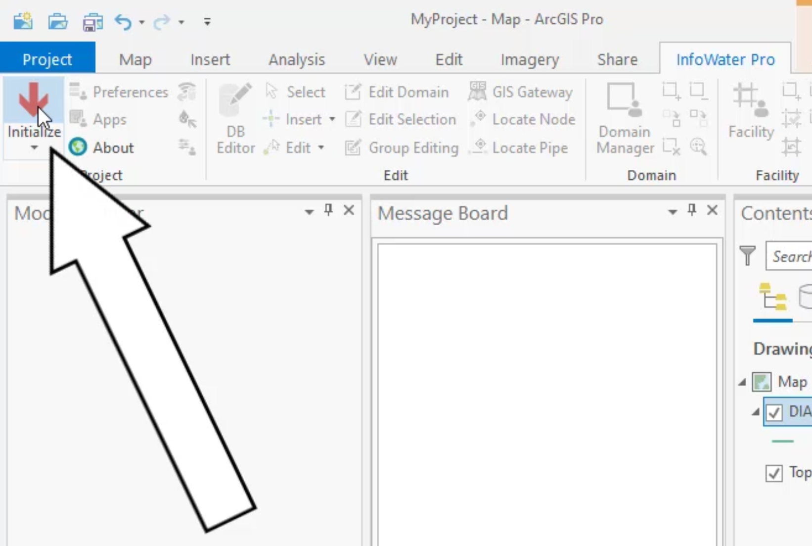
  2. From the ribbon, InfoWater Pro tab, click Initialize.The InfoWater Pro tab of the ribbon with Initialize called out as being selected
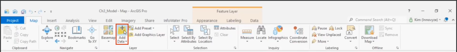
  3. From the ArcGIS Pro toolbar, Map tab, Layer panel, click Add Data.
    The Map tab, Layer panel, with the Add Data tool highlighted
  4. In the Add Data dialog box, browse to and double-click the desired .gdb file to expand it, such as CityData.gdb for this exercise.
  5. Select the raster data set you need, in this case, elevation.
    The ArcGIS Add Data file browser, with the elevation dataset selected
  6. Click OK.
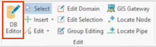
  7. On the InfoWater Pro ribbon, in the Edit panel, click DB Editor.
    The InfoWater Pro ribbon, Edit panel, with the DB Editor highlighted
  8. In the Open Table – Junction Information dialog box, Data Table tab, expand the Element Information Data folder.
  9. Double-click Junction Information.
    The Open Table - Junction Information dialog box open, with the Data Table folder tree active and the Element Information folder expanded, and with Junction Information selected

The Junction Information table populates the DB Editor. Notice that the Elevation column is empty.

  1. Click Exit to close the DB Editor.
    The DB Editor, Junction Information table, with the Elevation column highlighted because it is empty of data

You can use the Elevation Extractor to populate the elevation information, but be aware that this tool only accepts raster files.

  1. From the Command Center tab in the Model Explorer, expand the Tools folder.
  2. Double-click Elevation Extractor.
    The Model Explorer, Command Center tab, Tools folder with Elevation Extractor highlighted
  3. In the Elevation Extractor dialog box, set the Source Layer to elevation. (If you do not see “elevation” listed here as a layer, then the elevation data is likely in another file type.)
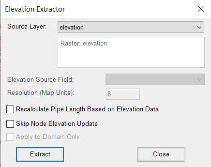
    The Elevation Extractor dialog box, with the Source Layer set to elevation and no other options enabled
  4. Click Extract.

The Elevation Extractor takes the value of the pixel corresponding to each junction and assigns it in the Elevation field of the InfoWater Pro Information Database Table.

  1. When you see a confirmation in the Message Board that the elevation data extraction is finished, close the extractor.
    Message Board confirmation
  2. Re-open the database editor by selecting DB Editor > Element Information Data > Junction Information.

You can see that elevation data is now contained in the database table:

The DB Editor, Junction Information table, with the Elevation column highlighted because it is now filled with the data from the elevation raster file

Was this information helpful?